
Courtelary topographic map
Interactive map
Click on the map to display elevation.
About this map
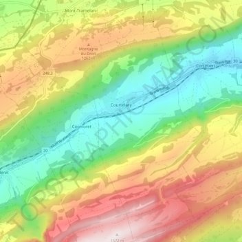
Name: Courtelary topographic map, elevation, terrain.
Average elevation: 1,059 m
Minimum elevation: 671 m
Maximum elevation: 1,571 m
Other topographic maps
Click on a map to view its topography, its elevation and its terrain.
Chaindon
Switzerland > Bern > Bernese Jura administrative district > Reconvilier
Chaindon, Reconvilier, Bernese Jura administrative district, Bernese Jura administrative region, Bern, 2732, Switzerland
Average elevation: 845 m
La Neuveville
Switzerland > Bern > Bernese Jura administrative district
La Neuveville, Bernese Jura administrative district, Bernese Jura administrative region, Bern, 2520, Switzerland
Average elevation: 642 m
Renan (BE)
Switzerland > Bern > Bernese Jura administrative district > Renan (BE)
Renan (BE), Bernese Jura administrative district, Bernese Jura administrative region, Bern, 2616, Switzerland
Average elevation: 1,073 m