
Gasabo District topographic map
Interactive map
Click on the map to display elevation.
About this map
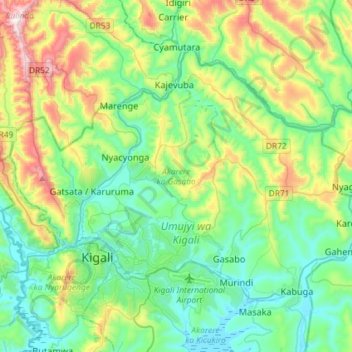
Name: Gasabo District topographic map, elevation, terrain.
Location: Gasabo District, Kigali City, Rwanda (-1.98884 29.98965 -1.77934 30.27987)
Average elevation: 1,574 m
Minimum elevation: 1,336 m
Maximum elevation: 2,226 m
Other topographic maps
Click on a map to view its topography, its elevation and its terrain.
Gisozi
Rwanda > Kigali City > Gasabo District
Gisozi, Gasabo District, Kigali City, Rwanda
Average elevation: 1,430 m
Gasabo
Rwanda > Kigali City > Gasabo District
Gasabo, Gasabo District, Kigali City, Rwanda
Average elevation: 1,456 m