
Lanslebourg-Mont-Cenis topographic map
Interactive map
Click on the map to display elevation.
About this map
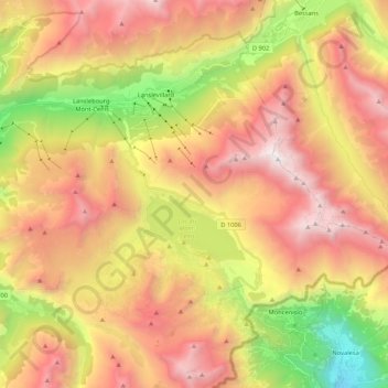
Name: Lanslebourg-Mont-Cenis topographic map, elevation, terrain.
Average elevation: 2,251 m
Minimum elevation: 732 m
Maximum elevation: 3,600 m
Other topographic maps
Click on a map to view its topography, its elevation and its terrain.
Grande Motte
France > Auvergne-Rhône-Alpes > Savoy > Val-Cenis
Grande Motte, Val-Cenis, Saint-Jean-de-Maurienne, Savoy, Auvergne-Rhône-Alpes, Metropolitan France, France
Average elevation: 2,957 m
Val-Cenis
France > Auvergne-Rhône-Alpes > Savoy > Val-Cenis
Val-Cenis, Saint-Jean-de-Maurienne, Savoy, Auvergne-Rhône-Alpes, Metropolitan France, 73480, France
Average elevation: 2,341 m