
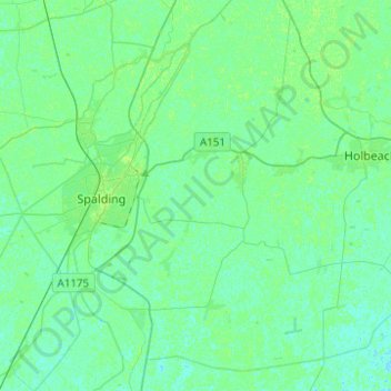
Weston CP topographic map
Interactive map
Click on the map to display elevation.
About this map
Name: Weston CP topographic map, elevation, terrain.
Average elevation: 3 m
Minimum elevation: -1 m
Maximum elevation: 8 m
Other topographic maps
Click on a map to view its topography, its elevation and its terrain.
Crowland
United Kingdom > England > South Holland > Crowland
Crowland, South Holland, Lincolnshire, East Midlands, England, PE6 0ED, United Kingdom
Average elevation: 3 m
Gedney Hill
United Kingdom > England > South Holland
Gedney Hill, South Holland, Lincolnshire, East Midlands, England, United Kingdom
Average elevation: 2 m
Lutton
United Kingdom > England > South Holland > Lutton
Lutton, South Holland, Lincolnshire, East Midlands, England, PE12 9HE, United Kingdom
Average elevation: 4 m
Hop Pole
United Kingdom > England > South Holland > Hop Pole
Hop Pole, Deeping St. Nicholas, South Holland, Lincolnshire, East Midlands, England, PE11 3HW, United Kingdom
Average elevation: 3 m
Weston Hills
United Kingdom > England > South Holland > Weston Hills
Weston Hills, South Holland, Lincolnshire, East Midlands, England, PE12 6DA, United Kingdom
Average elevation: 3 m
Sutton St Edmund
United Kingdom > England > South Holland > Sutton St Edmund
Sutton St Edmund, South Holland, Lincolnshire, East Midlands, England, PE12 0LT, United Kingdom
Average elevation: 1 m
Saracen's Head
United Kingdom > England > South Holland > Saracen's Head
Saracen's Head, South Holland, Lincolnshire, East Midlands, England, PE12 8TA, United Kingdom
Average elevation: 4 m
Pode Hole
United Kingdom > England > South Holland > Pode Hole
Pode Hole, South Holland, Lincolnshire, East Midlands, England, PE11 3LL, United Kingdom
Average elevation: 3 m
Gosberton
United Kingdom > England > South Holland > Gosberton
Gosberton, South Holland, Lincolnshire, East Midlands, England, PE11 4NJ, United Kingdom
Average elevation: 4 m
Holbeach Drove
United Kingdom > England > South Holland > Holbeach Drove
Holbeach Drove, South Holland, Lincolnshire, East Midlands, England, PE12 0PX, United Kingdom
Average elevation: 2 m
Long Sutton
United Kingdom > England > South Holland > Long Sutton
Long Sutton, South Holland, Lincolnshire, East Midlands, England, PE12 9FW, United Kingdom
Average elevation: 3 m
Throckenholt
United Kingdom > England > South Holland
Throckenholt, South Holland, Lincolnshire, East Midlands, England, PE12 0QW, United Kingdom
Average elevation: 2 m
Donington
United Kingdom > England > South Holland > Donington
Donington, Lincolnshire, East Midlands, England, PE11 4SZ, United Kingdom
Average elevation: 3 m
Deeping St Nicholas
United Kingdom > England > South Holland > Deeping St Nicholas
Deeping St Nicholas, Lincolnshire, East Midlands, England, PE11 3DG, United Kingdom
Average elevation: 2 m
Vernatt's Drain
United Kingdom > England > South Holland
Vernatt's Drain, South Holland, Lincolnshire, East Midlands, England, PE11 4DH, United Kingdom
Average elevation: 4 m
Holbeach St Matthew
United Kingdom > England > South Holland > Holbeach CP > Holbeach St Matthew
Holbeach St Matthew, Holbeach CP, South Holland, Lincolnshire, East Midlands, England, PE12 8EQ, United Kingdom
Average elevation: 4 m