
Ludington topographic map
Interactive map
Click on the map to display elevation.
About this map
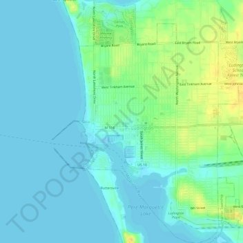
Name: Ludington topographic map, elevation, terrain.
Location: Ludington, Mason County, Michigan, United States (43.93532 -86.46967 43.97788 -86.41566)
Average elevation: 184 m
Minimum elevation: 175 m
Maximum elevation: 201 m
Other topographic maps
Click on a map to view its topography, its elevation and its terrain.
Buttersville Park
United States > Michigan > Mason County > Ludington
Buttersville Park, Ludington, Pere Marquette Charter Township, Mason County, Michigan, 49431, United States
Average elevation: 182 m
Cranberry Lake
United States > Michigan > Mason County
Cranberry Lake, Sheridan Township, Mason County, Michigan, United States
Average elevation: 228 m
Mason County
United States > Michigan > Mason County
Mason County, Michigan, United States
Average elevation: 210 m
Hamlin Lake
United States > Michigan > Mason County > Hamlin Lake
Hamlin Lake, Hamlin Township, Mason County, Michigan, United States
Average elevation: 189 m