
Crichton topographic map
Interactive map
Click on the map to display elevation.
About this map
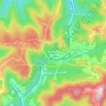
Name: Crichton topographic map, elevation, terrain.
Average elevation: 955 m
Minimum elevation: 820 m
Maximum elevation: 1,113 m
Other topographic maps
Click on a map to view its topography, its elevation and its terrain.
Alderson
United States > West Virginia > Greenbrier County > Alderson
Alderson, Greenbrier County, West Virginia, 24910, United States
Average elevation: 503 m
Alvon
United States > West Virginia > Greenbrier County > Alvon
Alvon, Greenbrier County, West Virginia, United States
Average elevation: 680 m
Lewisburg
United States > West Virginia > Greenbrier County
Lewisburg, Greenbrier County, West Virginia, 24901, United States
Average elevation: 661 m