
Randa topographic map
Interactive map
Click on the map to display elevation.
About this map
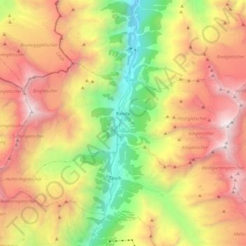
Name: Randa topographic map, elevation, terrain.
Location: Randa, Visp, Wallis, 3928, Switzerland (46.06479 7.68955 46.12600 7.86866)
Average elevation: 2,804 m
Minimum elevation: 1,211 m
Maximum elevation: 4,532 m
Other topographic maps
Click on a map to view its topography, its elevation and its terrain.
Saas-Almagell
Switzerland > Wallis > Visp
Saas-Almagell, Visp, Wallis, 3905, Switzerland
Average elevation: 2,830 m
Zermatt
Switzerland > Wallis > Visp
Zermatt, Visp, Wallis, 3920, Switzerland
Average elevation: 2,921 m
Monte Rosa
Switzerland > Wallis > Visp > Zermatt
Monte Rosa, Zermatt, Visp, Wallis, 3920, Switzerland
Average elevation: 4,033 m
Matterhorn
Switzerland > Wallis > Visp > Zermatt
Matterhorn, Zermatt, Visp, Wallis, 3920, Switzerland
Average elevation: 3,295 m
Gornergrat
Switzerland > Wallis > Visp > Zermatt
Gornergrat, Gornergrat - Hohtälli, Zermatt, Visp, Wallis, 3920, Switzerland
Average elevation: 2,768 m