
Алтайские горы topographic map
Interactive map
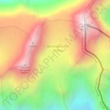
Click on the map to display elevation.
About this map
Name: Алтайские горы topographic map, elevation, terrain.
Average elevation: 3,898 m
Minimum elevation: 3,222 m
Maximum elevation: 4,490 m
In the north of the region is the Sailughem Mountains, also known as Kolyvan Altai, which stretch northeast from 49° N and 86° E towards the western extremity of the Sayan Mountains in 51° 60' N and 89° E. Their mean elevation is 1,500 to 1,750 m. The snow-line runs at 2,000 m on the northern side and at 2,400 m on the southern, and above it the rugged peaks tower some 1,000 m higher. Mountain passes across the range are few and difficult, the chief being the Ulan-daban at 2,827 m (2,879 m according to Kozlov), and the Chapchan-daban, at 3,217 m, in the south and north respectively. On the east and southeast this range is flanked by the great plateau of Mongolia, the transition being affected gradually by means of several minor plateaus, such as Ukok (2,380 m) with Pazyryk Valley, Chuya (1,830 m), Kendykty (2,500 m), Kak (2,520 m), (2,590 m), and (2,410 m).
Other topographic maps
Click on a map to view its topography, its elevation and its terrain.
Ust-Koksa
Russia > Altai Republic > Ust-Koksinsky Rayon
Ust-Koksa, Усть-Коксинское сельское поселение, Ust-Koksinsky Rayon, Altai Republic, Siberian Federal District, 649490, Russia
Average elevation: 1,031 m