
Sauda topographic map
Interactive map
Click on the map to display elevation.
About this map
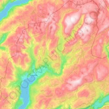
Name: Sauda topographic map, elevation, terrain.
Location: Sauda, Rogaland, Norway (59.56260 6.17810 59.84457 6.69351)
Average elevation: 793 m
Minimum elevation: -1 m
Maximum elevation: 1,593 m
Other topographic maps
Click on a map to view its topography, its elevation and its terrain.
Vassfjellet
Vassfjellet, Sandbakk, Sandnes, Rogaland, 4309, Norway
Average elevation: 124 m
Store Stokkavatn
Store Stokkavatn, Eiganes og Våland, Stavanger, Rogaland, Norway
Average elevation: 21 m