
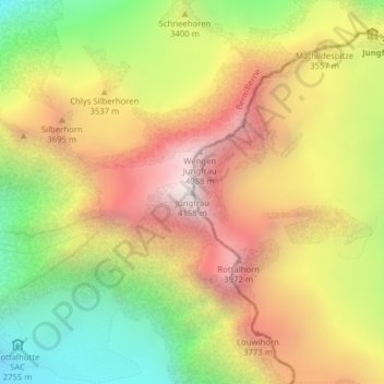
Jungfrau topographic map
Interactive map
Click on the map to display elevation.
About this map
Name: Jungfrau topographic map, elevation, terrain.
Average elevation: 3,401 m
Minimum elevation: 2,638 m
Maximum elevation: 4,128 m
The difference of altitude between the deep valley of Lauterbrunnen (800 m or 2,600 ft) and the summit is particularly visible from the area of Mürren. From the valley floor, west of the massif, the altitude gain is more than 3 km (1.9 mi) for a horizontal distance of 4 km (2.5 mi).
Other topographic maps
Click on a map to view its topography, its elevation and its terrain.
Mutthorn
Switzerland > Bern > Interlaken-Oberhasli administrative district > Lauterbrunnen
Mutthorn, Lauterbrunnen, Interlaken-Oberhasli administrative district, Oberland administrative region, Bern, Switzerland
Average elevation: 2,801 m
Birg
Switzerland > Bern > Interlaken-Oberhasli administrative district > Lauterbrunnen
Birg, Lauterbrunnen, Interlaken-Oberhasli administrative district, Oberland administrative region, Bern, 3825, Switzerland
Average elevation: 2,311 m
Jungfraujoch
Switzerland > Bern > Interlaken-Oberhasli administrative district > Lauterbrunnen
Jungfraujoch, Lauterbrunnen, Interlaken-Oberhasli administrative district, Oberland administrative region, Bern, 3801, Switzerland
Average elevation: 3,307 m