
Wacken topographic map
Interactive map
Click on the map to display elevation.
About this map
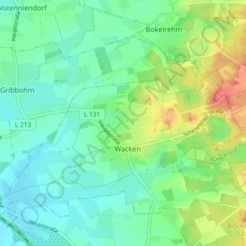
Name: Wacken topographic map, elevation, terrain.
Average elevation: 19 m
Minimum elevation: -1 m
Maximum elevation: 62 m
Other topographic maps
Click on a map to view its topography, its elevation and its terrain.
Krempe
Germany > Schleswig-Holstein > Kreis Steinburg > Krempe
Krempe, Krempermarsch, Kreis Steinburg, Schleswig-Holstein, Germany
Average elevation: 0 m
Horst
Germany > Schleswig-Holstein > Kreis Steinburg
Horst, Horst-Herzhorn, Kreis Steinburg, Schleswig-Holstein, 25358, Germany
Average elevation: 5 m