
Senoia topographic map
Interactive map
Click on the map to display elevation.
About this map
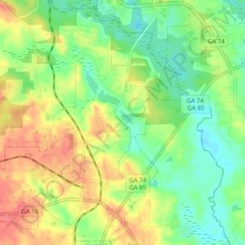
Name: Senoia topographic map, elevation, terrain.
Location: Senoia, Coweta County, Georgia, United States (33.28713 -84.59043 33.34199 -84.52233)
Average elevation: 248 m
Minimum elevation: 219 m
Maximum elevation: 285 m
Other topographic maps
Click on a map to view its topography, its elevation and its terrain.
Arnco Mills
United States > Georgia > Coweta County
Arnco Mills, Coweta County, Georgia, 30275, United States
Average elevation: 256 m
Grantville
United States > Georgia > Coweta County > Grantville
Grantville, Coweta County, Georgia, United States
Average elevation: 245 m
Newnan
United States > Georgia > Coweta County
Newnan, Coweta County, Georgia, 30263, United States
Average elevation: 272 m