
Chinon topographic map
Interactive map
Click on the map to display elevation.
About this map
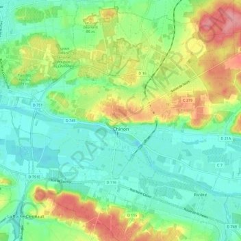
Name: Chinon topographic map, elevation, terrain.
Average elevation: 58 m
Minimum elevation: 24 m
Maximum elevation: 124 m
Topography has played a major role: the formerly fortified town was developed at the foot of the castle on the rocky outcrop, protecting the northern side, with the Vienne River in the south. Apart from the natural defensive protection on both sides, this fact makes a long narrow urban space, with the main streets running parallel to the river.
Other topographic maps
Click on a map to view its topography, its elevation and its terrain.
Saché
France > Centre-Val de Loire > Indre-et-Loire
Saché, Tours, Indre-et-Loire, Centre-Val de Loire, Metropolitan France, 37190, France
Average elevation: 86 m
Larçay
France > Centre-Val de Loire > Indre-et-Loire
Larçay, Tours, Indre-et-Loire, Centre-Val de Loire, Metropolitan France, 37270, France
Average elevation: 81 m
La Boiselle
France > Centre-Val de Loire > Indre-et-Loire > Dierre
La Boiselle, Les Devants du Prieuré, Dierre, Loches, Indre-et-Loire, Centre-Val de Loire, Metropolitan France, 37150, France
Average elevation: 76 m
Château-la-Vallière
France > Centre-Val de Loire > Indre-et-Loire
Château-la-Vallière, Chinon, Indre-et-Loire, Centre-Val de Loire, Metropolitan France, 37330, France
Average elevation: 96 m
Le Bourg
France > Centre-Val de Loire > Indre-et-Loire > Cinq-Mars-la-Pile
Le Bourg, Cinq-Mars-la-Pile, Chinon, Indre-et-Loire, Centre-Val de Loire, Metropolitan France, 37130, France
Average elevation: 62 m
Le Bourg
France > Centre-Val de Loire > Indre-et-Loire > Fondettes
Le Bourg, Fondettes, Tours, Indre-et-Loire, Centre-Val de Loire, Metropolitan France, 37230, France
Average elevation: 83 m
Saint-Flovier
France > Centre-Val de Loire > Indre-et-Loire
Saint-Flovier, Loches, Indre-et-Loire, Centre-Val de Loire, Metropolitan France, 37600, France
Average elevation: 135 m
Marcilly-sur-Vienne
France > Centre-Val de Loire > Indre-et-Loire
Marcilly-sur-Vienne, Chinon, Indre-et-Loire, Centre-Val de Loire, Metropolitan France, 37800, France
Average elevation: 62 m
Le Bois Turbet
France > Centre-Val de Loire > Indre-et-Loire > Marcé-sur-Esves
Le Bois Turbet, Marcé-sur-Esves, Loches, Indre-et-Loire, Centre-Val de Loire, Metropolitan France, 37160, France
Average elevation: 82 m
La Bérangerie
France > Centre-Val de Loire > Indre-et-Loire > Saint-Jean-Saint-Germain
La Bérangerie, Saint-Jean-Saint-Germain, Loches, Indre-et-Loire, Centre-Val de Loire, Metropolitan France, 37600, France
Average elevation: 108 m
Descartes
France > Centre-Val de Loire > Indre-et-Loire
Descartes, Loches, Indre-et-Loire, Centre-Val de Loire, Metropolitan France, 37160, France
Average elevation: 90 m
Tours
France > Centre-Val de Loire > Indre-et-Loire
Tours, Indre-et-Loire, Centre-Val de Loire, Metropolitan France, France
Average elevation: 73 m
Amboise
France > Centre-Val de Loire > Indre-et-Loire
Amboise, Loches, Indre-et-Loire, Centre-Val de Loire, Metropolitan France, 37400, France
Average elevation: 91 m
Ciran
France > Centre-Val de Loire > Indre-et-Loire
Ciran, Loches, Indre-et-Loire, Centre-Val de Loire, Metropolitan France, 37240, France
Average elevation: 103 m
Varton
France > Centre-Val de Loire > Indre-et-Loire > Boussay
Varton, Boussay, Loches, Indre-et-Loire, Centre-Val de Loire, Metropolitan France, 37290, France
Average elevation: 109 m