
Holderness topographic map
Interactive map
Click on the map to display elevation.
Holderness
According to the United States Census Bureau, the town has a total area of 35.7 square miles (92.5 km2), of which 30.3 square miles (78.6 km2) are land and 5.4 square miles (13.9 km2) are water, comprising 15.05% of the town.[1] Bounded on the northwest by the Pemigewasset River, Holderness is drained by Owl Brook and the Squam River. Part of Squam Lake is in the east, and Little Squam Lake is in the center. Mount Prospect, with an elevation of 2,064 feet (629 m) above sea level, is in the north. The highest point in Holderness is Mount Webster in the northeast part of the town, elevation 2,076 feet (633 m) and part of the Squam Range. Via the Pemigewasset River, Holderness lies fully within the Merrimack River watershed.[7]
About this map
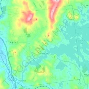
Name: Holderness topographic map, elevation, terrain.
Average elevation: 252 m
Minimum elevation: 138 m
Maximum elevation: 654 m
Other topographic maps
Click on a map to view its topography, its elevation and its terrain.
Stinson Lake
United States > New Hampshire > Grafton County > Rumney > Stinson Lake
Average elevation: 460 m
Mount Kineo, East Peak
United States > New Hampshire > Grafton County > Ellsworth
Average elevation: 710 m
West Lebanon
United States > New Hampshire > Grafton County > Lebanon > West Lebanon
Average elevation: 165 m
North Littleton
United States > New Hampshire > Grafton County > Littleton > North Littleton
Average elevation: 333 m
LeBruns Mobile Home Park
United States > New Hampshire > Grafton County > Lebanon > LeBruns Mobile Home Park
Average elevation: 326 m