
Nakuru topographic map
Interactive map
Click on the map to display elevation.
About this map
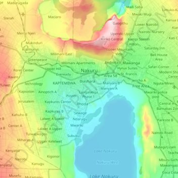
Name: Nakuru topographic map, elevation, terrain.
Location: Nakuru, Kenya (-0.35577 36.01620 -0.24231 36.19426)
Average elevation: 1,921 m
Minimum elevation: 1,754 m
Maximum elevation: 2,276 m
Other topographic maps
Click on a map to view its topography, its elevation and its terrain.
Barut ward
Kenya > Nakuru > Nakuru West
Barut ward, Nakuru West, Nakuru, Rift Valley, Kenya
Average elevation: 1,888 m