
Bourges topographic map
Interactive map
Click on the map to display elevation.
About this map
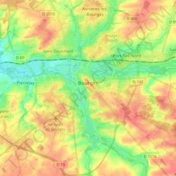
Name: Bourges topographic map, elevation, terrain.
Average elevation: 146 m
Minimum elevation: 118 m
Maximum elevation: 172 m
Other topographic maps
Click on a map to view its topography, its elevation and its terrain.
Crux
France > Centre-Val de Loire > Cher > Villequiers
Crux, Villequiers, Bourges, Cher, Centre-Val de Loire, Metropolitan France, 18800, France
Average elevation: 196 m
Culan
France > Centre-Val de Loire > Cher
Culan, Saint-Amand-Montrond, Cher, Centre-Val de Loire, Metropolitan France, 18270, France
Average elevation: 291 m
Bertrix
France > Centre-Val de Loire > Cher > Clémont
Bertrix, Clémont, Vierzon, Cher, Centre-Val de Loire, Metropolitan France, 18410, France
Average elevation: 148 m
Jouet-sur-l'Aubois
France > Centre-Val de Loire > Cher
Jouet-sur-l'Aubois, Saint-Amand-Montrond, Cher, Centre-Val de Loire, Metropolitan France, 18320, France
Average elevation: 187 m
Mornay-sur-Allier
France > Centre-Val de Loire > Cher
Mornay-sur-Allier, Saint-Amand-Montrond, Cher, Centre-Val de Loire, Metropolitan France, 18600, France
Average elevation: 199 m
Vernais
France > Centre-Val de Loire > Cher
Vernais, Saint-Amand-Montrond, Cher, Centre-Val de Loire, Metropolitan France, 18210, France
Average elevation: 195 m
Ourouer-les-Bourdelins
France > Centre-Val de Loire > Cher
Ourouer-les-Bourdelins, Saint-Amand-Montrond, Cher, Centre-Val de Loire, Metropolitan France, 18350, France
Average elevation: 208 m
Précy
France > Centre-Val de Loire > Cher
Précy, Bourges, Cher, Centre-Val de Loire, Metropolitan France, 18140, France
Average elevation: 188 m
Le Chautay
France > Centre-Val de Loire > Cher
Le Chautay, Saint-Amand-Montrond, Cher, Centre-Val de Loire, Metropolitan France, 18150, France
Average elevation: 193 m
Bué
France > Centre-Val de Loire > Cher
Bué, Bourges, Cher, Centre-Val de Loire, Metropolitan France, 18300, France
Average elevation: 264 m
Marseilles
France > Centre-Val de Loire > Cher > Marseilles-lès-Aubigny
Marseilles, Marseilles-lès-Aubigny, Bourges, Cher, Centre-Val de Loire, Metropolitan France, 18320, France
Average elevation: 177 m
Vierzon
France > Centre-Val de Loire > Cher
Vierzon, Cher, Centre-Val de Loire, Metropolitan France, 18100, France
Average elevation: 137 m
Nohant-en-Graçay
France > Centre-Val de Loire > Cher
Nohant-en-Graçay, Vierzon, Cher, Centre-Val de Loire, Metropolitan France, 18310, France
Average elevation: 138 m