
Powidz topographic map
Interactive map
Click on the map to display elevation.
About this map
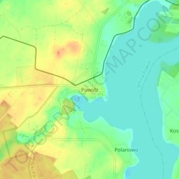
Name: Powidz topographic map, elevation, terrain.
Average elevation: 107 m
Minimum elevation: 90 m
Maximum elevation: 131 m
Other topographic maps
Click on a map to view its topography, its elevation and its terrain.
Młodojewo-Parcele
Poland > Greater Poland Voivodeship > Słupca County
Młodojewo-Parcele, gmina Słupca, Słupca County, Greater Poland Voivodeship, 62-400, Poland
Average elevation: 97 m
Bielsko
Poland > Greater Poland Voivodeship > Słupca County
Bielsko, gmina Orchowo, Słupca County, Greater Poland Voivodeship, 62-436, Poland
Average elevation: 107 m
Meszna
Poland > Greater Poland Voivodeship > Słupca County
Meszna, gmina Słupca, Słupca County, Greater Poland Voivodeship, 62-400, Poland
Average elevation: 99 m
Róża
Poland > Greater Poland Voivodeship > Słupca County
Róża, gmina Słupca, Słupca County, Greater Poland Voivodeship, 62-400, Poland
Average elevation: 94 m