
Rapid City topographic map
Interactive map
Click on the map to display elevation.
About this map
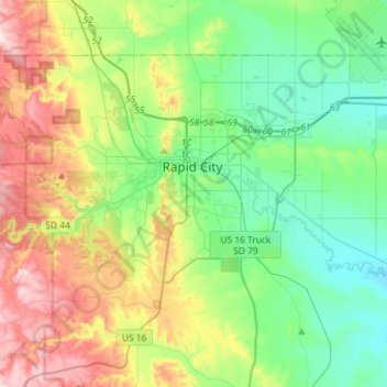
Name: Rapid City topographic map, elevation, terrain.
Location: Rapid City, Pennington County, South Dakota, United States (43.99492 -103.32635 44.13679 -103.03791)
Average elevation: 1,068 m
Minimum elevation: 914 m
Maximum elevation: 1,390 m
Rapid City is located at 44°04′34″N 103°13′42″W / 44.076188°N 103.228299°W / 44.076188; -103.228299. The downtown elevation of Rapid City is 3,202 feet (976 m). Rapid City is located in the shadow of Black Elk Peak, which at 7,242 feet (2,207 m), is the highest point east of the Rocky Mountains.
Other topographic maps
Click on a map to view its topography, its elevation and its terrain.
Black Hills
United States > South Dakota > Pennington County
Black Hills, Pennington County, South Dakota, United States
Average elevation: 1,894 m
Moon
United States > South Dakota > Pennington County
Moon, Pennington County, South Dakota, United States
Average elevation: 1,938 m
Mount Rushmore
United States > South Dakota > Pennington County
Mount Rushmore, Pennington County, South Dakota, 57751, United States
Average elevation: 1,562 m
Rapid Creek
United States > South Dakota > Pennington County
Rapid Creek, Pennington County, South Dakota, United States
Average elevation: 1,689 m
Mount Rushmore National Memorial
United States > South Dakota > Pennington County
Mount Rushmore National Memorial, Pennington County, South Dakota, United States
Average elevation: 1,528 m
Rapid Valley
United States > South Dakota > Pennington County > Rapid Valley
Rapid Valley, Pennington County, South Dakota, 57703-6649, United States
Average elevation: 977 m