
Kisumu topographic map
Interactive map
Click on the map to display elevation.
About this map
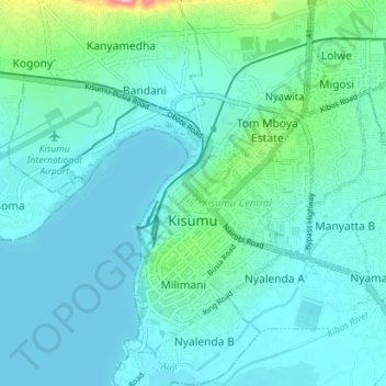
Name: Kisumu topographic map, elevation, terrain.
Location: Kisumu, Kisumu County, Nyanza, 40100, Kenya (-0.13552 34.67275 -0.03467 34.82763)
Average elevation: 1,219 m
Minimum elevation: 1,132 m
Maximum elevation: 1,715 m
Kisumu literally means a place of barter trade "sumo". The city has "Friendship" status with Cheltenham, United Kingdom and "sister city" status with Roanoke, Virginia and Boulder, Colorado, United States. It sits at an elevation of 1,131 m (3,711 ft). Kisumu is 200 miles north west of Nairobi and its located at the shores of Lake Victoria. It lies at the northeastern edge of the Winam Gulf, a long, shallow arm that protrudes from the main body of Lake Victoria. Kisumu is set 15 miles south of the Equator and has moderate temperatures because of its elevation of 3000+ ft. above sea level. Just four hours away by car is the massive Kenya National Game Preserve, the Masai Mara, a world-renowned safari attraction. Kisumu is a few kilometers South of the equator, so the days are always around 12 hours long and sunset is always between 1840h and 1900h.The metropolitan region comprises the city and its suburbs and satellite towns of Maseno, Kondele and Ahero .
Other topographic maps
Click on a map to view its topography, its elevation and its terrain.
Andingo Bware
Kenya > Kisumu County > Nyakach > South West Nyakach ward
Andingo Bware, South West Nyakach ward, Nyakach, Kisumu County, Kenya
Average elevation: 1,431 m
Kisumu
Kisumu, City of Kisumu, Kisumu County, Nyanza, 40100, Kenya
Average elevation: 1,310 m
Ainopngtuny/samjut Harji
Ainopngtuny/samjut Harji, Kisumu County, Nyanza, Kenya
Average elevation: 1,239 m
Kajulu Rakwaro
Kenya > Kisumu County > Kajulu Rakwaro
Kajulu Rakwaro, Kisumu County, Nyanza, Kenya
Average elevation: 1,143 m
Maseno
Kenya > Kisumu County > Kisumu West
Maseno, Kisumu West, Kisumu County, Nyanza, Kenya
Average elevation: 1,533 m