
Oadby topographic map
Interactive map
Click on the map to display elevation.
About this map
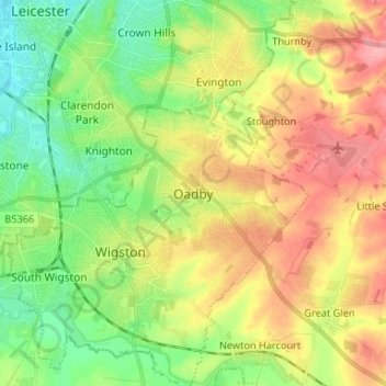
Name: Oadby topographic map, elevation, terrain.
Average elevation: 98 m
Minimum elevation: 55 m
Maximum elevation: 152 m
Other topographic maps
Click on a map to view its topography, its elevation and its terrain.
Kilby Bridge
United Kingdom > England > Leicestershire > Oadby and Wigston > Wigston
Kilby Bridge, Wigston, Oadby and Wigston, Leicestershire, England, LE18 3TF, United Kingdom
Average elevation: 89 m
Wigston
United Kingdom > England > Leicestershire > Oadby and Wigston
Wigston, Oadby and Wigston, Leicestershire, England, LE18 1DT, United Kingdom
Average elevation: 91 m