
Athens topographic map
Interactive map
Click on the map to display elevation.
About this map
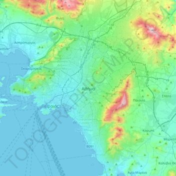
Name: Athens topographic map, elevation, terrain.
Average elevation: 168 m
Minimum elevation: -3 m
Maximum elevation: 1,091 m
Owing to the rain shadow of the Pindus Mountains, annual precipitation of Athens is lower than most other parts of Greece, especially western Greece. As an example, Ioannina receives around 1,300 mm (51 in) per year, and Agrinio around 800 mm (31 in) per year. Daily average highs for July have been measured around 34 °C or 93 °F in downtown Athens, but some parts of the city may be even hotter for the higher density of buildings, and the lower density of vegetation, such as the center, in particular, western areas due to a combination of industrialization and a number of natural factors, knowledge of which has existed since the mid-19th century. Due to the large area covered by Athens Metropolitan Area, there are notable climatic differences between parts of the urban conglomeration. The northern suburbs tend to be wetter and cooler in winter, whereas the southern suburbs are some of the driest locations in Greece and record very high minimum temperatures in summer. Heavy snow fell in the Greater Athens area and Athens itself between 14–17 February 2021, when snow blanketed the entire city and its suburbs from the north to the furthest south, coastal suburbs, with depth ranges up to 25 centimetres (9.8 in) in Central Athens., and with even the Acropolis of Athens completely covered with snow. The National Meteorological Service (EMY) described it was one of the most intense snow storms over the past 40 years. Heavy snow was also reported in Athens on January 24, 2022, with 40 centimetres (16 in) reported locally in the higher elevations.
Other topographic maps
Click on a map to view its topography, its elevation and its terrain.
Lycabettus
Greece > Attica > Regional Unit of Central Athens > Athens
Lycabettus, Δώρας Δ' Ίστρια, Kolonaki, Συνοικία Κολωνακίου, 1st District of Athens, Athens, Municipality of Athens, Regional Unit of Central Athens, Attica, 106 76, Greece
Average elevation: 125 m
Dourgouti Region
Greece > Attica > Regional Unit of Central Athens > Athens
Dourgouti Region, Dourgouti, 2nd District of Athens, Athens, Municipality of Athens, Regional Unit of Central Athens, Attica, Greece
Average elevation: 73 m
Philopappos Hill
Greece > Attica > Regional Unit of Central Athens > Athens
Philopappos Hill, Athens, Municipality of Athens, Regional Unit of Central Athens, Attica, 117 41, Greece
Average elevation: 73 m
Άλσος Βεΐκου
Greece > Attica > Regional Unit of Central Athens > Athens
Άλσος Βεΐκου, Galatsi, Athens, Municipality of Galatsi, Regional Unit of Central Athens, Attica, Greece
Average elevation: 171 m
Municipality of Vyronas
Greece > Attica > Regional Unit of Central Athens
Municipality of Vyronas, Regional Unit of Central Athens, Attica, Greece
Average elevation: 276 m
Municipality of Ilioupoli
Greece > Attica > Regional Unit of Central Athens
Municipality of Ilioupoli, Regional Unit of Central Athens, Attica, Greece
Average elevation: 350 m
Ιλισσός
Greece > Attica > Regional Unit of Central Athens > Athens
Ιλισσός, 7th District of Athens, Athens, Municipality of Athens, Regional Unit of Central Athens, Attica, 11527, Greece
Average elevation: 140 m
Municipality of Galatsi
Greece > Attica > Regional Unit of Central Athens
Municipality of Galatsi, Regional Unit of Central Athens, Attica, Greece
Average elevation: 176 m