
Geneva topographic map
Interactive map
Click on the map to display elevation.
About this map
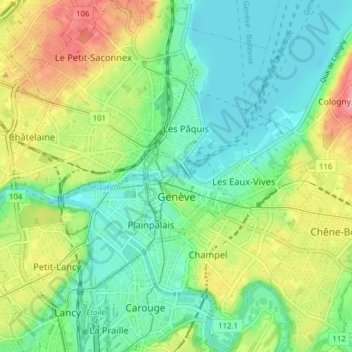
Name: Geneva topographic map, elevation, terrain.
Location: Geneva, Switzerland (46.17777 6.11024 46.23189 6.17585)
Average elevation: 404 m
Minimum elevation: 367 m
Maximum elevation: 474 m
The altitude of Geneva is 373.6 m (1,225.7 ft) and corresponds to the altitude of the largest of the Pierres du Niton, two large rocks emerging from the lake which date from the last ice age. This rock was chosen by General Guillaume Henri Dufour as the reference point for surveying in Switzerland. The second main river of Geneva is the Arve, which flows into the Rhône just west of the city centre. Mont Blanc can be seen from Geneva and is an hour's drive from the city.
Other topographic maps
Click on a map to view its topography, its elevation and its terrain.
Dardagny Castle
Switzerland > Geneva > Dardagny
Dardagny Castle, 520, Route du Mandement, Dardagny, Geneva, 1283, Switzerland
Average elevation: 431 m
Le Grand-Saconnex
Switzerland > Geneva > Le Grand-Saconnex > Le Grand-Saconnex
Le Grand-Saconnex, Grand Genève, Geneva, 1218, Switzerland
Average elevation: 414 m
Le Grand-Saconnex
Le Grand-Saconnex, Geneva, 1218, Switzerland
Average elevation: 429 m