
Kakamega topographic map
Interactive map
Click on the map to display elevation.
About this map
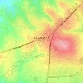
Name: Kakamega topographic map, elevation, terrain.
Location: Kakamega, Kakamega County, West Kenya, Kenya (0.26468 34.73366 0.29895 34.76834)
Average elevation: 1,533 m
Minimum elevation: 1,458 m
Maximum elevation: 1,592 m
Kakamega is 52 km north of Kisumu, the tenth largest city in Kenya and considered the heart of Luhya land. The average elevation of Kakamega is 1,535 metres.
Other topographic maps
Click on a map to view its topography, its elevation and its terrain.
Mumias
Kenya > Kakamega County > Mumias
Mumias, Kakamega County, West Kenya, Kenya
Average elevation: 1,297 m