
Make a donation
Gear up for your next adventure:
As an Amazon Associate, this site earns from qualifying purchases at no extra cost to you.
City of Ithaca topographic map
Click on the map to display elevation.
Make a donation
Gear up for your next adventure:
As an Amazon Associate, this site earns from qualifying purchases at no extra cost to you.
About this map
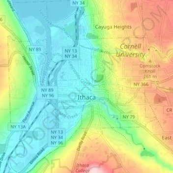
Name: City of Ithaca topographic map, elevation, terrain.
Location: City of Ithaca, Tompkins County, New York, United States (42.41816 -76.52700 42.46709 -76.46999)
Average elevation: 195 m
Minimum elevation: 111 m
Maximum elevation: 347 m
Make a donation
Gear up for your next adventure:
As an Amazon Associate, this site earns from qualifying purchases at no extra cost to you.
Other topographic maps
Click on a map to view its topography, its elevation and its terrain.
Trumbull Corners
United States > New York > Tompkins County > Town of Newfield
Average elevation: 443 m
Hartung-Boothroyd Observatory
United States > New York > Tompkins County > Town of Dryden > Varna
The primary 0.6m mirror was constructed from a Pyrex 1/8-scale test pouring as part of technology development for the Palomar Observatory 200-inch telescope. The mirror was polished and mounted in a lightweight tube in the late 1930s under Boothroyd's direction, but World War II deferred its planned use in a…
Average elevation: 477 m
Make a donation
Gear up for your next adventure:
As an Amazon Associate, this site earns from qualifying purchases at no extra cost to you.