
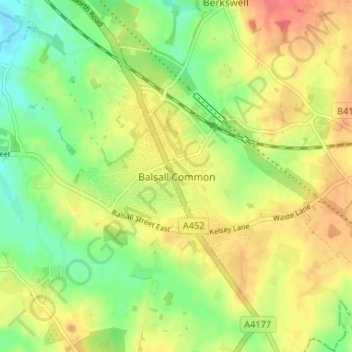
Balsall Common topographic map
Interactive map
Click on the map to display elevation.
About this map
Name: Balsall Common topographic map, elevation, terrain.
Average elevation: 117 m
Minimum elevation: 90 m
Maximum elevation: 143 m
Other topographic maps
Click on a map to view its topography, its elevation and its terrain.
Waring's Green
United Kingdom > England > Metropolitan Borough of Solihull > Cheswick Green > Illshaw Heath
Waring's Green, Illshaw Heath, Cheswick Green, Metropolitan Borough of Solihull, West Midlands Combined Authority, England, B94 6BP, United Kingdom
Average elevation: 139 m
Temple Balsall
United Kingdom > England > Metropolitan Borough of Solihull
Temple Balsall, Balsall, Metropolitan Borough of Solihull, West Midlands Combined Authority, England, B93 0AN, United Kingdom
Average elevation: 109 m
Little Clowes Wood
United Kingdom > England > Metropolitan Borough of Solihull > Tidbury Green
Little Clowes Wood, Wood Lane, Tidbury Green, Metropolitan Borough of Solihull, West Midlands Combined Authority, England, B94 5JL, United Kingdom
Average elevation: 150 m
Four Oaks
United Kingdom > England > Metropolitan Borough of Solihull
Four Oaks, Metropolitan Borough of Solihull, West Midlands Combined Authority, England, CV7 7SL, United Kingdom
Average elevation: 121 m
Coleshill Heath
United Kingdom > England > Metropolitan Borough of Solihull
Coleshill Heath, Metropolitan Borough of Solihull, West Midlands Combined Authority, England, B37 7PD, United Kingdom
Average elevation: 96 m
Knowle
United Kingdom > England > Metropolitan Borough of Solihull
Knowle, Metropolitan Borough of Solihull, West Midlands Combined Authority, England, B93 9NR, United Kingdom
Average elevation: 119 m
Barston
United Kingdom > England > Metropolitan Borough of Solihull
Barston, Metropolitan Borough of Solihull, West Midlands Combined Authority, England, United Kingdom
Average elevation: 104 m
Hockley Heath
United Kingdom > England > Metropolitan Borough of Solihull
Hockley Heath, Metropolitan Borough of Solihull, West Midlands Combined Authority, England, United Kingdom
Average elevation: 134 m
Elmdon Heath
United Kingdom > England > Metropolitan Borough of Solihull
Elmdon Heath, Metropolitan Borough of Solihull, West Midlands Combined Authority, England, B91 2SA, United Kingdom
Average elevation: 120 m
Monkspath
United Kingdom > England > Metropolitan Borough of Solihull
Monkspath, Metropolitan Borough of Solihull, West Midlands Combined Authority, England, B90 4SZ, United Kingdom
Average elevation: 133 m
Blossomfield
United Kingdom > England > Metropolitan Borough of Solihull
Blossomfield, Metropolitan Borough of Solihull, West Midlands Combined Authority, England, B91 1TP, United Kingdom
Average elevation: 137 m
Haslucks Green
United Kingdom > England > Metropolitan Borough of Solihull
Haslucks Green, Metropolitan Borough of Solihull, West Midlands Combined Authority, England, B90 1BF, United Kingdom
Average elevation: 143 m
Tidbury Green
United Kingdom > England > Metropolitan Borough of Solihull
Tidbury Green, Metropolitan Borough of Solihull, West Midlands Combined Authority, England, United Kingdom
Average elevation: 149 m