
Chattanooga topographic map
Interactive map
Click on the map to display elevation.
About this map
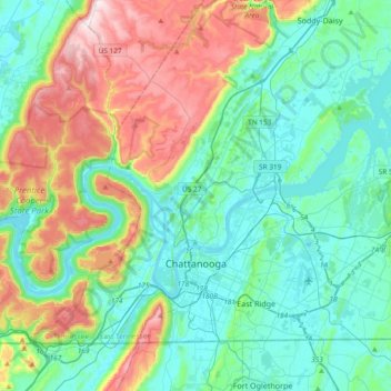
Name: Chattanooga topographic map, elevation, terrain.
Average elevation: 331 m
Minimum elevation: 189 m
Maximum elevation: 722 m
According to the United States Census Bureau, the city has a total area of 144.6 square miles (374.4 km2), of which 137.1 square miles (355.2 km2) are land and 7.4 square miles (19.2 km2), or 5.12%, are water. The most prominent natural features in and around Chattanooga are the Tennessee River and the surrounding mountains. The Tennessee River is impounded by the Chickamauga Dam north of the downtown area. The city is nestled between the southwestern Ridge-and-valley Appalachians and the foot of Walden's Ridge; the river separates the ridge from the western side of downtown. Several miles east, the city is bisected by Missionary Ridge. The downtown area sits at an elevation of approximately 676 feet (206 m), one of the lowest elevations in East Tennessee.
Other topographic maps
Click on a map to view its topography, its elevation and its terrain.
Tennessee River
United States > Tennessee > Hamilton County > Chattanooga
Tennessee River, Chattanooga, Hamilton County, East Tennessee, Tennessee, United States
Average elevation: 225 m
East Brainerd
United States > Tennessee > Hamilton County
East Brainerd, Hamilton County, East Tennessee, Tennessee, United States
Average elevation: 267 m
Carriage Hill
United States > Tennessee > Hamilton County > Signal Mountain
Carriage Hill, Signal Mountain, Hamilton County, Tennessee, 37377, United States
Average elevation: 391 m
South Brainerd
United States > Tennessee > Hamilton County > Chattanooga > East Ridge
South Brainerd, East Ridge, Chattanooga, Hamilton County, East Tennessee, Tennessee, 37412, United States
Average elevation: 223 m
Gaylan Heights
United States > Tennessee > Hamilton County > Chattanooga
Gaylan Heights, Chattanooga, Hamilton County, Tennessee, 37406, United States
Average elevation: 228 m
Soddy-Daisy
United States > Tennessee > Hamilton County
Soddy-Daisy, Hamilton County, East Tennessee, Tennessee, United States
Average elevation: 346 m
Falling Water
United States > Tennessee > Hamilton County
Falling Water, Hamilton County, East Tennessee, Tennessee, United States
Average elevation: 323 m
Brookfield
United States > Tennessee > Hamilton County > East Ridge > Brookfield
Brookfield, East Ridge, Hamilton County, Tennessee, 37412, United States
Average elevation: 235 m
Soddy-Daisy
United States > Tennessee > Hamilton County > Soddy-Daisy > Soddy-Daisy
Soddy-Daisy, Hamilton County, Tennessee, 37379, United States
Average elevation: 307 m
Chattanooga
United States > Tennessee > Hamilton County > Chattanooga
Chattanooga, Hamilton County, Tennessee, 818, United States
Average elevation: 311 m
Soddy
United States > Tennessee > Hamilton County > Soddy-Daisy
Soddy, Soddy-Daisy, Hamilton County, East Tennessee, Tennessee, 47379, United States
Average elevation: 299 m
Lower Mill
United States > Tennessee > Hamilton County > Chattanooga
Lower Mill, Chattanooga, Hamilton County, Tennessee, 37343, United States
Average elevation: 217 m
Northshore Estates
United States > Tennessee > Hamilton County > Chattanooga > Northshore Estates
Northshore Estates, Chattanooga, Hamilton County, Tennessee, 37416, United States
Average elevation: 223 m
Bakewell
United States > Tennessee > Hamilton County > Bakewell
Bakewell, Hamilton County, Tennessee, 37304, United States
Average elevation: 269 m
Signal Mountain
United States > Tennessee > Hamilton County
Signal Mountain, Hamilton County, Tennessee, 37377, United States
Average elevation: 493 m