
Make a donation
Gear up for your next adventure:
As an Amazon Associate, this site earns from qualifying purchases at no extra cost to you.
Erzurum topographic map
Click on the map to display elevation.
Make a donation
Gear up for your next adventure:
As an Amazon Associate, this site earns from qualifying purchases at no extra cost to you.
Erzurum
Six kilometres to the south of the center of Erzurum is an important skiing center on the Palandöken Mountain range. There are several ski runs; the south ski run is eight km long, while the north ski run is intended for advanced skiers. The summit of Mt. Palandöken, which is called Büyük Ejder (Great Dragon), is at an altitude of 3188 metres. It can be reached with a chairlift which rises to an altitude of 3100 metres.
Make a donation
Gear up for your next adventure:
As an Amazon Associate, this site earns from qualifying purchases at no extra cost to you.
About this map
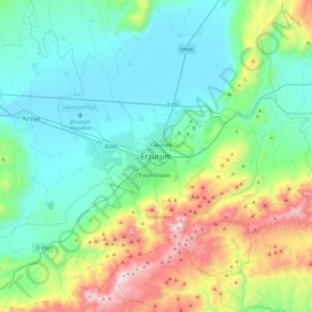
Name: Erzurum topographic map, elevation, terrain.
Average elevation: 2,089 m
Minimum elevation: 1,750 m
Maximum elevation: 3,166 m
Make a donation
Gear up for your next adventure:
As an Amazon Associate, this site earns from qualifying purchases at no extra cost to you.
Other topographic maps
Click on a map to view its topography, its elevation and its terrain.