
Phoenicia topographic map
Interactive map
Click on the map to display elevation.
About this map
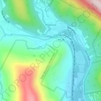
Name: Phoenicia topographic map, elevation, terrain.
Average elevation: 349 m
Minimum elevation: 227 m
Maximum elevation: 680 m
Other topographic maps
Click on a map to view its topography, its elevation and its terrain.
Rocky Mountain
United States > New York > Ulster County > Town of Shandaken
Rocky Mountain, Town of Shandaken, Ulster County, New York, United States
Average elevation: 924 m
Catskills Visitor Center
United States > New York > Ulster County > Town of Shandaken > Beechford
Catskills Visitor Center, Beechford, Town of Shandaken, Ulster County, New York, United States
Average elevation: 301 m
Mount Tremper
United States > New York > Ulster County > Town of Shandaken
Mount Tremper, Town of Shandaken, Ulster County, New York, 12457, United States
Average elevation: 343 m