
Cle Elum topographic map
Interactive map
Click on the map to display elevation.
Cle Elum
Cle Elum has a humid continental climate, Köppen subtype Dsb. The elevation is 1909 feet and temperatures are cooler than areas to the east. The coldest month is December, a trait common in the Pacific Northwest. But hot temperatures still occur, and not just in summer: on March 18, 1968, the temperature soared to 95 °F.[17]
About this map
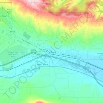
Name: Cle Elum topographic map, elevation, terrain.
Location: Cle Elum, Kittitas County, Washington, United States (47.18434 -121.01610 47.20680 -120.90000)
Average elevation: 696 m
Minimum elevation: 561 m
Maximum elevation: 1,058 m
Other topographic maps
Click on a map to view its topography, its elevation and its terrain.
Cathedral Rock
United States > Washington > Kittitas County
Cathedral Rock is an intrusive andesite volcanic complex. The Alpine Lakes Wilderness features some of the most rugged topography in the Cascade Range with craggy peaks and ridges, deep glacial valleys, and granite walls spotted with over 700 mountain lakes. Geological events occurring many years ago created…
Average elevation: 1,547 m