
Hamad Town topographic map
Interactive map
Click on the map to display elevation.
About this map
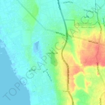
Name: Hamad Town topographic map, elevation, terrain.
Location: Hamad Town, Northern Governorate, 1203, Bahrain (26.08675 50.45834 26.16675 50.53834)
Average elevation: 16 m
Minimum elevation: -3 m
Maximum elevation: 55 m
Other topographic maps
Click on a map to view its topography, its elevation and its terrain.
Budaiya
Bahrain > Northern Governorate
Budaiya, Northern Governorate, 533, Bahrain
Average elevation: 3 m
Malkiyah Walkway
Bahrain > Northern Governorate > Karzakan
Malkiyah Walkway, Karzakan, Northern Governorate, Bahrain
Average elevation: 2 m
A'ali
Bahrain > Northern Governorate > A'ali
A'ali, Northern Governorate, 38886, Bahrain
Average elevation: 6 m