
Larissa topographic map
Interactive map
Click on the map to display elevation.
About this map
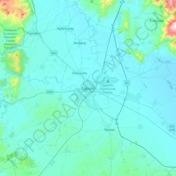
Name: Larissa topographic map, elevation, terrain.
Average elevation: 128 m
Minimum elevation: 47 m
Maximum elevation: 1,073 m
Other topographic maps
Click on a map to view its topography, its elevation and its terrain.
Falani
Greece > Thessaly and Central Greece > Larisa Regional Unit > Municipal Unit of Yiannouli
Falani, Municipal Unit of Yiannouli, Municipality of Larissa, Larisa Regional Unit, Thessaly, Thessaly and Central Greece, 400 11, Greece
Average elevation: 68 m
Tyrnavos Municipality
Greece > Thessaly and Central Greece > Larisa Regional Unit
Tyrnavos Municipality, Larisa Regional Unit, Thessaly, Thessaly and Central Greece, Greece
Average elevation: 297 m
Όλυμπος
Greece > Thessaly and Central Greece > Larisa Regional Unit > Elassona Municipality
Όλυμπος, Elassona Municipality, Larisa Regional Unit, Thessaly, Thessaly and Central Greece, Greece
Average elevation: 2,456 m
Gonni
Greece > Thessaly and Central Greece > Larisa Regional Unit > Gonni
Gonni, Tempi Municipality, Larisa Regional Unit, Thessaly, Thessaly and Central Greece, 40004, Greece
Average elevation: 239 m
Σαραντάπορο
Greece > Thessaly and Central Greece > Larisa Regional Unit > Elassona Municipality > Σαραντάπορο
Σαραντάπορο, Elassona Municipality, Larisa Regional Unit, Thessaly, Thessaly and Central Greece, 40200, Greece
Average elevation: 797 m