
Assisi topographic map
Interactive map
Click on the map to display elevation.
About this map
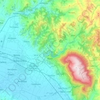
Name: Assisi topographic map, elevation, terrain.
Location: Assisi, Perugia, Umbria, 06081, Italy (43.01078 12.51072 43.15870 12.72712)
Average elevation: 436 m
Minimum elevation: 179 m
Maximum elevation: 1,286 m
Other topographic maps
Click on a map to view its topography, its elevation and its terrain.
Ponticelli
Ponticelli is a frazione of the comune of Città della Pieve in the Province of Perugia, Umbria, central Italy. It stands at an elevation of 249 metres above sea level. At the time of the Istat census of 2001 it had 610 inhabitants.
Average elevation: 275 m