
Lake Toba topographic map
Interactive map
Click on the map to display elevation.
Lake Toba
Lake Toba (Indonesian: Danau Toba, Toba Batak: ᯖᯀᯬ ᯖᯬᯅ; romanized: Tao Toba) is a large natural lake in North Sumatra, Indonesia, occupying the caldera of a supervolcano. The lake is located in the middle of the northern part of the island of Sumatra, with a surface elevation of about 900 metres (2,953 ft), the lake stretches from 2°53′N 98°31′E / 2.88°N 98.52°E / 2.88; 98.52 to 2°21′N 99°06′E / 2.35°N 99.1°E / 2.35; 99.1. The lake is about 100 kilometres (62 miles) long, 30 kilometres (19 mi) wide, and up to 505 metres (1,657 ft) deep. It is the largest lake in Indonesia and the largest volcanic lake in the world. Toba Caldera is one of twenty geoparks in Indonesia, and was recognised in July 2020 as one of the UNESCO Global Geoparks.
About this map
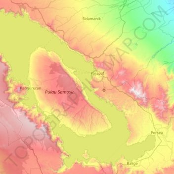
Name: Lake Toba topographic map, elevation, terrain.
Location: Lake Toba, North Sumatra, Sumatra, Indonesia (2.31860 98.51838 2.90311 99.15221)
Average elevation: 1,079 m
Minimum elevation: 199 m
Maximum elevation: 2,183 m
Other topographic maps
Click on a map to view its topography, its elevation and its terrain.
Batang Onang
Indonesia > North Sumatra > Northern Padang Lawas > Sayur Matinggi Ii (julu)
Average elevation: 275 m
Batang Angkola
Indonesia > North Sumatra > Kota Padang Sidempuan–Tapanuli Selatan > Padang Sidempuan
Average elevation: 611 m