
South-East District topographic map
Interactive map
Click on the map to display elevation.
About this map
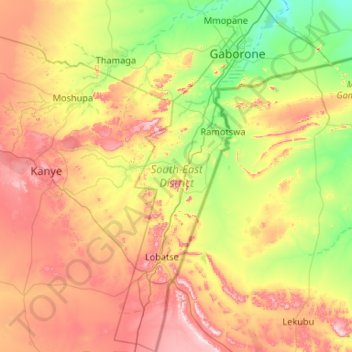
Name: South-East District topographic map, elevation, terrain.
Location: South-East District, Botswana (-25.46789 25.53901 -24.51263 26.18860)
Average elevation: 1,162 m
Minimum elevation: 948 m
Maximum elevation: 1,530 m
In the southeast, South-East borders the North West Province of South Africa. Domestically, it borders Kgatleng in northeast, Kweneng in northwest, Southern in southwest. Most part of Botswana has tableland slopes sliding from east to west. The region has an average elevation of around 915 m (3,002 ft) above the mean sea level. The vegetation type is Savannah, with tall grasses, bushes and trees. The annual precipitation is around 65 cm (26 in), most of which is received during the summer season from November to May. Most of the rivers in the region are seasonal, with Limpopo River, which are prone to flash floods, being the most prominent. Mokolodi Nature Reserve, Gaborone Game Reserve and Manyelanong Game Reserve are the major tourist places in the district.
Other topographic maps
Click on a map to view its topography, its elevation and its terrain.
Mabuasehube
Mabuasehube, Kgalagadi District, Botswana
Average elevation: 1,045 m
Lokgwabe
Lokgwabe, Kgalagadi District, Botswana
Average elevation: 1,116 m
Boteti River
Boteti River, Central District, Botswana
Average elevation: 914 m
Okavango Delta
Botswana > North-West District
Okavango Delta, North-West District, Botswana
Average elevation: 959 m
Chobe National Park
Chobe National Park, Chobe District, Botswana
Average elevation: 964 m
Makgadikgadi Pans Game Reserve
Makgadikgadi Pans Game Reserve, Central District, Botswana
Average elevation: 917 m
Gaborone
Botswana > South-East District
Gaborone, South-East District, Botswana
Average elevation: 1,032 m
Jwaneng
Botswana > Southern District > Jwaneng
Jwaneng, Southern District, Botswana
Average elevation: 1,193 m
Selebi Phikwe
Botswana > Central District > Selebi Phikwe
Selebi Phikwe, Central District, Botswana
Average elevation: 863 m
Khwai
Botswana > North-West District > Khwai
Khwai, North-West District, Botswana
Average elevation: 939 m
Kalahari Desert
Kalahari Desert, Ghanzi District, Botswana
Average elevation: 1,168 m
Francistown
Botswana > North-East District > Francistown
Francistown, North-East District, Botswana
Average elevation: 1,007 m
Pandamatenga
Pandamatenga, Chobe District, Botswana
Average elevation: 1,074 m
Gaborone Dam
Botswana > South-East District > Gaborone
Gaborone Dam, Gaborone, South-East District, Botswana
Average elevation: 992 m
Letlhakane
Botswana > Central District > Letlhakane
Letlhakane, Central District, NULL, Botswana
Average elevation: 990 m