
Phoenix-See topographic map
Interactive map
Click on the map to display elevation.
About this map
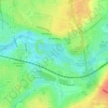
Name: Phoenix-See topographic map, elevation, terrain.
Average elevation: 116 m
Minimum elevation: 93 m
Maximum elevation: 151 m
Other topographic maps
Click on a map to view its topography, its elevation and its terrain.
Freibad Froschloch
Germany > North Rhine-Westphalia > Dortmund
Freibad Froschloch, 103, Löttringhauser Straße, Löttringhausen, Hombruch, Dortmund, North Rhine-Westphalia, 44225, Germany
Average elevation: 111 m
Lütgendortmund-Ost
Germany > North Rhine-Westphalia > Dortmund
Lütgendortmund-Ost, Dortmund, North Rhine-Westphalia, Germany
Average elevation: 96 m
Westfalenpark
Germany > North Rhine-Westphalia > Dortmund
Westfalenpark, Mitte, Dortmund, Regierungsbezirk Arnsberg, North Rhine-Westphalia, 44139, Germany
Average elevation: 110 m