
Mils topographic map
Interactive map
Click on the map to display elevation.
About this map
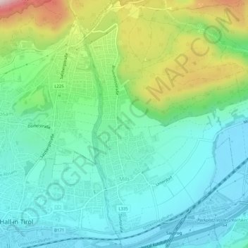
Name: Mils topographic map, elevation, terrain.
Location: Mils, Bezirk Innsbruck-Land, 6068, Austria (47.27807 11.52080 47.31202 11.55557)
Average elevation: 670 m
Minimum elevation: 550 m
Maximum elevation: 988 m
Other topographic maps
Click on a map to view its topography, its elevation and its terrain.
Puig
Austria > Bezirk Innsbruck-Land > Steinach am Brenner
Puig, Steinach am Brenner, Bezirk Innsbruck-Land, 6143, Austria
Average elevation: 1,302 m
Mützens
Austria > Bezirk Innsbruck-Land > Matrei am Brenner > Mühlbachl
Mützens, Mühlbachl, Matrei am Brenner, Bezirk Innsbruck-Land, 6143, Austria
Average elevation: 1,282 m
Brenner Pass
Austria > Bezirk Innsbruck-Land > Gries am Brenner > Brenner
Brenner Pass, Brenner, Gries am Brenner, Bezirk Innsbruck-Land, 6156, Austria
Average elevation: 1,635 m