
Belitsa topographic map
Interactive map
Click on the map to display elevation.
About this map
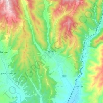
Name: Belitsa topographic map, elevation, terrain.
Location: Belitsa, Blagoevgrad, 2780, Bulgaria (41.91106 23.51920 41.99106 23.59920)
Average elevation: 941 m
Minimum elevation: 758 m
Maximum elevation: 1,254 m
Other topographic maps
Click on a map to view its topography, its elevation and its terrain.
Belasica
Belasica, Petrich, Blagoevgrad, 2880, Bulgaria
Average elevation: 1,582 m
Tuhovishta
Tuhovishta, Satovcha, Blagoevgrad, 2939, Bulgaria
Average elevation: 765 m
Алантепе
Алантепе, Belitsa, Blagoevgrad, 2785, Bulgaria
Average elevation: 1,512 m
Goce Delcev
Goce Delcev, Gotse Delchev, Blagoevgrad, 2900, Bulgaria
Average elevation: 705 m
Goreme
Bulgaria > Blagoevgrad > Goreme
Goreme, Strumiani, Blagoevgrad, 2834, Bulgaria
Average elevation: 747 m