
Prenton Brook topographic map
Interactive map
Click on the map to display elevation.
About this map
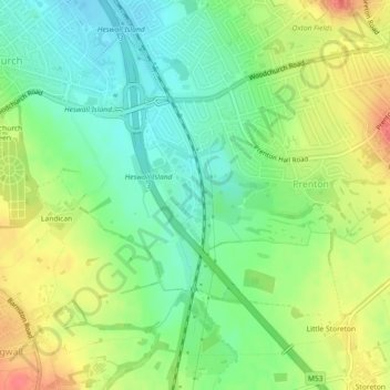
Name: Prenton Brook topographic map, elevation, terrain.
Average elevation: 38 m
Minimum elevation: 12 m
Maximum elevation: 72 m
Other topographic maps
Click on a map to view its topography, its elevation and its terrain.
Birkenhead Park
United Kingdom > England > Wirral
Birkenhead Park, Claughton, Wirral, North West England, England, United Kingdom
Average elevation: 23 m
The Birket
United Kingdom > England > Wirral
The Birket, Wirral, North West England, England, CH41 7EL, United Kingdom
Average elevation: 15 m
Greasby Brook
United Kingdom > England > Wirral
Greasby Brook, Wirral, North West England, England, CH48 1PT, United Kingdom
Average elevation: 19 m
Arrowe Brook
United Kingdom > England > Wirral
Arrowe Brook, Wirral, North West England, England, CH46 5NP, United Kingdom
Average elevation: 17 m
The Beacons
United Kingdom > England > Wirral
The Beacons, Beacon Lane, Woodchurch, Wirral, North West England, England, CH60 0BY, United Kingdom
Average elevation: 56 m