
McCracken County topographic map
Interactive map
Click on the map to display elevation.
About this map
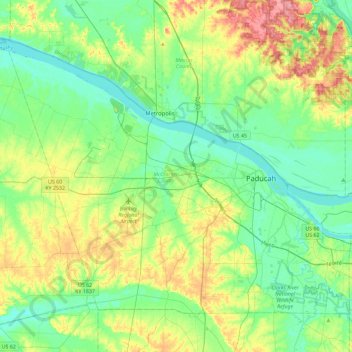
Name: McCracken County topographic map, elevation, terrain.
Location: McCracken County, Kentucky, United States (36.94188 -88.94221 37.22885 -88.48286)
Average elevation: 119 m
Minimum elevation: 90 m
Maximum elevation: 186 m
Other topographic maps
Click on a map to view its topography, its elevation and its terrain.
Louisville
United States > Kentucky > Jefferson County
Louisville, Jefferson County, Kentucky, United States
Average elevation: 188 m
Paducah
United States > Kentucky > McCracken County
Paducah, McCracken County, Kentucky, United States
Average elevation: 108 m
Owensboro
United States > Kentucky > Daviess County
Owensboro, Daviess County, Kentucky, United States
Average elevation: 123 m
Bowling Green
United States > Kentucky > Warren County
Bowling Green, Warren County, Kentucky, 42101, United States
Average elevation: 169 m
Newport
United States > Kentucky > Campbell County
Newport, Campbell County, Kentucky, 41071, United States
Average elevation: 173 m
Somerset
United States > Kentucky > Pulaski County
Somerset, Pulaski County, Kentucky, 42503, United States
Average elevation: 295 m
Pathfork
United States > Kentucky > Harlan County
Pathfork, Harlan County, Kentucky, 40863, United States
Average elevation: 534 m
Lenarue
United States > Kentucky > Harlan County
Lenarue, Harlan County, Kentucky, 40818, United States
Average elevation: 519 m
Lone Star
United States > Kentucky > Hart County
Lone Star, Hart County, Kentucky, 42713, United States
Average elevation: 228 m
Sonora
United States > Kentucky > Hardin County
Sonora, Hardin County, Kentucky, United States
Average elevation: 221 m
Load
United States > Kentucky > Greenup County
Load, Greenup County, Kentucky, United States
Average elevation: 222 m
Hustonville
United States > Kentucky > Lincoln County
Hustonville, Lincoln County, Kentucky, United States
Average elevation: 316 m
Bardo
United States > Kentucky > Harlan County
Bardo, Harlan County, Kentucky, 40830, United States
Average elevation: 634 m
Holmes Mill
United States > Kentucky > Harlan County
Holmes Mill, Harlan County, Kentucky, 40843, United States
Average elevation: 758 m
Putney
United States > Kentucky > Harlan County
Putney, Harlan County, Kentucky, 40865, United States
Average elevation: 601 m
Uno
United States > Kentucky > Hart County
Uno, Hart County, Kentucky, United States
Average elevation: 201 m
Frankfort
United States > Kentucky > Franklin County
Frankfort, Franklin County, Kentucky, United States
Average elevation: 216 m
Inez
United States > Kentucky > Martin County
Inez, Martin County, Kentucky, 41224, United States
Average elevation: 253 m
Elkhorn City
United States > Kentucky > Pike County
Elkhorn City, Pike County, Kentucky, United States
Average elevation: 364 m
Walnut Hill
United States > Kentucky > Fayette County > Lexington
Walnut Hill, Lexington, Fayette County, Kentucky, 40509, United States
Average elevation: 311 m
Paint Lick
United States > Kentucky > Garrard County
Paint Lick, Garrard County, Kentucky, 40461, United States
Average elevation: 272 m
Sparrow
United States > Kentucky > Anderson County
Sparrow, Anderson County, Kentucky, United States
Average elevation: 230 m
Pansy
United States > Kentucky > Harlan County
Pansy, Harlan County, Kentucky, 40830, United States
Average elevation: 602 m
Boyd
United States > Kentucky > Harrison County
Boyd, Harrison County, Kentucky, 41003, United States
Average elevation: 214 m
Hardyville
United States > Kentucky > Hart County
Hardyville, Hart County, Kentucky, United States
Average elevation: 212 m
Alva
United States > Kentucky > Harlan County
Alva, Harlan County, Kentucky, 40863, United States
Average elevation: 652 m
Pine Mountain
United States > Kentucky > Harlan County
Pine Mountain, Harlan County, Kentucky, United States
Average elevation: 536 m
Leesburg
United States > Kentucky > Harrison County
Leesburg, Harrison County, Kentucky, United States
Average elevation: 280 m
Jonesville
United States > Kentucky > Hart County
Jonesville, Hart County, Kentucky, 42757, United States
Average elevation: 241 m
Frost
United States > Kentucky > Greenup County
Frost, Greenup County, Kentucky, 41175, United States
Average elevation: 180 m
Ages
United States > Kentucky > Harlan County
Ages, Harlan County, Kentucky, 40801, United States
Average elevation: 587 m
Saint John
United States > Kentucky > Hardin County
Saint John, Hardin County, Kentucky, 42724, United States
Average elevation: 237 m
Nolin
United States > Kentucky > Hardin County
Nolin, Hardin County, Kentucky, 42740, United States
Average elevation: 210 m
Wallins Creek
United States > Kentucky > Harlan County
Wallins Creek, Harlan County, Kentucky, United States
Average elevation: 416 m
Lejunior
United States > Kentucky > Harlan County
Lejunior, Harlan County, Kentucky, 40865, United States
Average elevation: 585 m
Three Point
United States > Kentucky > Harlan County
Three Point, Harlan County, Kentucky, 40815, United States
Average elevation: 475 m
Louellen
United States > Kentucky > Harlan County
Louellen, Harlan County, Kentucky, 40849, United States
Average elevation: 698 m
Broadwell
United States > Kentucky > Harrison County
Broadwell, Harrison County, Kentucky, United States
Average elevation: 264 m
Kenvir
United States > Kentucky > Harlan County
Kenvir, Harlan County, Kentucky, 40847, United States
Average elevation: 642 m
Hartford
United States > Kentucky > Ohio County
Hartford, Ohio County, Kentucky, United States
Average elevation: 123 m
Fresh Meadows
United States > Kentucky > Harlan County
Fresh Meadows, Harlan County, Kentucky, 40824, United States
Average elevation: 462 m
Yancey
United States > Kentucky > Harlan County
Yancey, Harlan County, Kentucky, 40830, United States
Average elevation: 651 m
Wolf
United States > Kentucky > Carter County
Wolf, Carter County, Kentucky, United States
Average elevation: 271 m
Howe Valley
United States > Kentucky > Hardin County
Howe Valley, Hardin County, Kentucky, United States
Average elevation: 221 m
Hardin Springs
United States > Kentucky > Hardin County
Hardin Springs, Hardin County, Kentucky, 40145, United States
Average elevation: 195 m
Big Laurel
United States > Kentucky > Harlan County
Big Laurel, Harlan County, Kentucky, 40808, United States
Average elevation: 574 m
Limp
United States > Kentucky > Hardin County
Limp, Hardin County, Kentucky, United States
Average elevation: 211 m
Cawood
United States > Kentucky > Harlan County
Cawood, Harlan County, Kentucky, 40818, United States
Average elevation: 498 m
White Mills
United States > Kentucky > Hardin County
White Mills, Hardin County, Kentucky, 42788, United States
Average elevation: 195 m