
Paintsville Lake topographic map
Interactive map
Click on the map to display elevation.
About this map
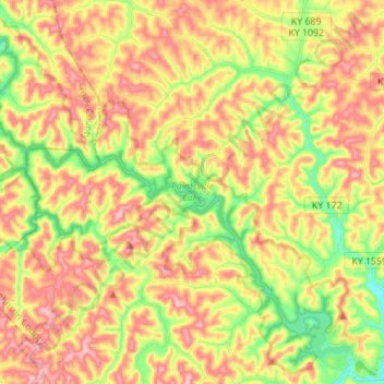
Name: Paintsville Lake topographic map, elevation, terrain.
Location: Paintsville Lake, Johnson County, Kentucky, United States (37.83675 -83.00892 37.93534 -82.87051)
Average elevation: 285 m
Minimum elevation: 188 m
Maximum elevation: 374 m
Other topographic maps
Click on a map to view its topography, its elevation and its terrain.
Paintsville Lake State Park
United States > Kentucky > Johnson County
Paintsville Lake State Park, Johnson County, Kentucky, United States
Average elevation: 241 m
Paintsville
United States > Kentucky > Johnson County
Paintsville, Johnson County, Kentucky, 41240, United States
Average elevation: 243 m
Paintsville
United States > Kentucky > Johnson County > Paintsville > Paintsville
Paintsville, Johnson County, Kentucky, 41240, United States
Average elevation: 243 m
Sitka
United States > Kentucky > Johnson County
Sitka, Johnson County, Kentucky, 41255, United States
Average elevation: 274 m
Volga
United States > Kentucky > Johnson County > Volga
Volga, Johnson County, Kentucky, 41255, United States
Average elevation: 267 m
Staffordsville
United States > Kentucky > Johnson County
Staffordsville, Johnson County, Kentucky, 41256, United States
Average elevation: 238 m
Dawkins
United States > Kentucky > Johnson County
Dawkins, Johnson County, Kentucky, 41268, United States
Average elevation: 238 m
West Van Lear
United States > Kentucky > Johnson County
West Van Lear, Johnson County, Kentucky, 41268, United States
Average elevation: 242 m