
Åreskutan topographic map
Interactive map
Click on the map to display elevation.
About this map
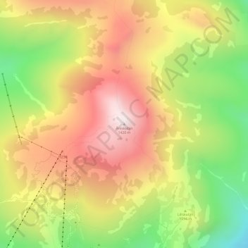
Name: Åreskutan topographic map, elevation, terrain.
Average elevation: 1,115 m
Minimum elevation: 774 m
Maximum elevation: 1,414 m
Other topographic maps
Click on a map to view its topography, its elevation and its terrain.
Högvålen
Högvålen, Härjedalens kommun, Jämtland County, Region Norrland, Sweden
Average elevation: 833 m
Frösön
Sweden > Jämtland County > Östersund
Frösön, Östersund, Jämtland County, Region Norrland, Sweden
Average elevation: 317 m
Havsnäs
Sweden > Jämtland County > Havsnäs
Havsnäs, Strömsund, Jämtland County, Region Norrland, Sweden
Average elevation: 309 m