
Enan topographic map
Interactive map
Click on the map to display elevation.
About this map
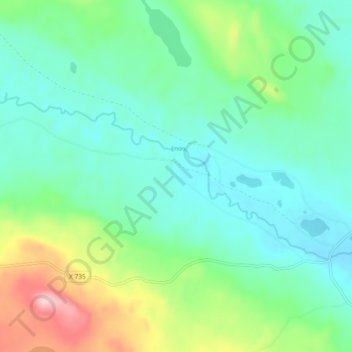
Name: Enan topographic map, elevation, terrain.
Average elevation: 263 m
Minimum elevation: 209 m
Maximum elevation: 418 m
Other topographic maps
Click on a map to view its topography, its elevation and its terrain.
Gävle
Sweden > Gävleborg County > Gävle
Gävle, Gävle kommun, Gävleborg County, Region Norrland, 80130, Sweden
Average elevation: 39 m
Province of Hälsingland
Province of Hälsingland, Gävleborg County, Region Norrland, Sweden
Average elevation: 181 m
Söderhamn
Sweden > Gävleborg County > Söderhamn
Söderhamn, Söderhamns kommun, Gävleborg County, Region Norrland, 82630, Sweden
Average elevation: 24 m
Ljusdal
Sweden > Gävleborg County > Ljusdal
Ljusdal, Province Hälsingland, Gävleborg County, Region Norrland, 82700, Sweden
Average elevation: 160 m
Morberget
Morberget, Hudiksvall, Province Hälsingland, Gävleborg County, Region Norrland, Sweden
Average elevation: 122 m
Limön
Sweden > Gävleborg County > Gävle
Limön, Gävle, Province Gästrikland, Gävleborg County, Region Norrland, Sweden
Average elevation: 1 m
Kölen
Kölen, Ljusdal, Province Hälsingland, Gävleborg County, Region Norrland, Sweden
Average elevation: 308 m
Garpkölen
Garpkölen, Ljusdal, Province Hälsingland, Gävleborg County, Region Norrland, Sweden
Average elevation: 487 m