
Mount Elbert topographic map
Interactive map
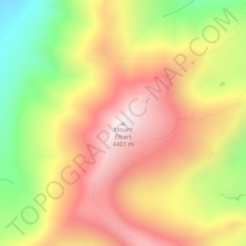
Click on the map to display elevation.
About this map
Name: Mount Elbert topographic map, elevation, terrain.
Location: Mount Elbert, Lake County, Colorado, United States (39.11793 -106.44510 39.11803 -106.44500)
Average elevation: 3,958 m
Minimum elevation: 3,421 m
Maximum elevation: 4,394 m
The summit of Mount Elbert at 14,440 feet (4401.2 m) elevation is the highest summit of the Rocky Mountains of North America, the highest point in the U.S. State of Colorado, and the second-highest summit in the contiguous United States after Mount Whitney. The ultra-prominent fourteener is the highest peak in the Sawatch Range, as well as the highest point in the entire Mississippi River drainage basin. Mount Elbert is located in San Isabel National Forest, 12.1 miles (19.4 km) southwest (bearing 223°) of the City of Leadville in Lake County, Colorado.
Other topographic maps
Click on a map to view its topography, its elevation and its terrain.
Mount Sherman
United States > Colorado > Lake County
Mount Sherman, Lake County, Colorado, United States
Average elevation: 3,989 m
Leadville
United States > Colorado > Lake County
Leadville, Lake County, Colorado, 80461, United States
Average elevation: 3,106 m
Leadville
United States > Colorado > Lake County
Leadville, Lake County, Colorado, 80461, United States
Average elevation: 3,106 m
Lake County
United States > Colorado > Lake County
Lake County, Colorado, United States
Average elevation: 3,398 m