
Shoshone Range topographic map
Interactive map
Click on the map to display elevation.
About this map
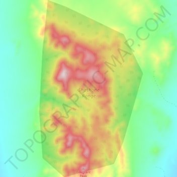
Name: Shoshone Range topographic map, elevation, terrain.
Location: Shoshone Range, Lander County, Nevada, USA (39.40145 -117.41627 39.47304 -117.36197)
Average elevation: 2,075 m
Minimum elevation: 1,860 m
Maximum elevation: 2,435 m
Other topographic maps
Click on a map to view its topography, its elevation and its terrain.
Ruby Mountains
Ruby Mountains, National Forest Development Road 343 Trail, Elko County, Nevada, USA
Average elevation: 1,962 m
River Mountains Loop Trail
USA > Nevada > Boulder City
River Mountains Loop Trail, Boulder City, Clark County, Nevada, 89005, USA
Average elevation: 756 m
Jeff Davis Peak
Jeff Davis Peak, White Pine County, Nevada, USA
Average elevation: 3,432 m
North Jackson Mountains Wilderness Area
North Jackson Mountains Wilderness Area, Jackson Creek Ranch Road, Humboldt County, Nevada, USA
Average elevation: 1,747 m
Snake Range
Snake Range, Great Basin National Park, White Pine County, Nevada, USA
Average elevation: 1,984 m
Wheeler Peak Glacier
Wheeler Peak Glacier, Bristlecone and Glacier Trail, White Pine County, Nevada, USA
Average elevation: 3,500 m
Whistler Mountain
Whistler Mountain, Eureka County, Nevada, USA
Average elevation: 2,211 m