
Saitama Prefecture topographic map
Interactive map
Click on the map to display elevation.
About this map
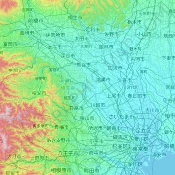
Name: Saitama Prefecture topographic map, elevation, terrain.
Location: Saitama Prefecture, Japan (35.75338 138.71136 36.28341 139.90033)
Average elevation: 230 m
Minimum elevation: -3 m
Maximum elevation: 2,041 m
The topography of Saitama Prefecture is largely divided by the Hachiōji Tectonic Line, which runs through Kodama, Ogawa, and Hannō, into the western mountain area and the eastern lowland area. The altitude, highest on the western side, gradually lowers eastward from mountain ranges to hills to plateaus to lowlands. The eastern lowlands and plateaus occupy 67.3% of the area.
Other topographic maps
Click on a map to view its topography, its elevation and its terrain.
Mount Fuji
Japan > Sunto County > Oyama
Mount Fuji, Oyama, Sunto County, Shizuoka Prefecture, Chubu Region, Japan
Average elevation: 3,261 m
Lake Sanaru
Lake Sanaru, Hamamatsu, Shizuoka Prefecture, Chubu Region, Japan
Average elevation: 16 m
Motoyama
Motoyama, Nagaoka County, Kochi Prefecture, 781-3601, Japan
Average elevation: 679 m
Setouchi
Setouchi, Oshima County, Kagoshima Prefecture, Japan
Average elevation: 26 m
Higashishirakawa
Higashishirakawa, Kamo County, Gifu Prefecture, Chubu Region, 509-1392, Japan
Average elevation: 658 m
Nishikigaoka-chuo Park
Nishikigaoka-chuo Park, Nishikigaoka 2-chome, Aoba Ward, Sendai, Miyagi Prefecture, Japan
Average elevation: 197 m
Katsura Imperial Villa
Katsura Imperial Villa, Road No. 142, Katsura-Kasugacho, Nishikyo Ward, Kyoto, Kyoto Prefecture, 615-8013, Japan
Average elevation: 25 m