
Yelets topographic map
Interactive map
Click on the map to display elevation.
About this map
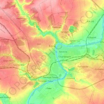
Name: Yelets topographic map, elevation, terrain.
Location: Yelets, Lipetsk Oblast, Central Federal District, Russia (52.57421 38.43003 52.65626 38.61437)
Average elevation: 165 m
Minimum elevation: 100 m
Maximum elevation: 219 m
Other topographic maps
Click on a map to view its topography, its elevation and its terrain.
Yelets
Russia > Lipetsk Oblast > Yelets > Yelets
Yelets, Lipetsk Oblast, Central Federal District, 399770, Russia
Average elevation: 186 m