
Kallmünz topographic map
Interactive map
Click on the map to display elevation.
About this map
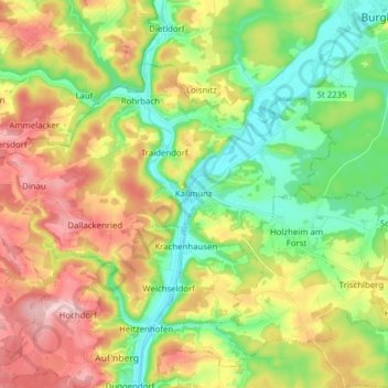
Name: Kallmünz topographic map, elevation, terrain.
Average elevation: 413 m
Minimum elevation: 335 m
Maximum elevation: 521 m
Other topographic maps
Click on a map to view its topography, its elevation and its terrain.
Mintraching
Germany > Bavaria > Landkreis Regensburg
Mintraching, Landkreis Regensburg, Bavaria, 93098, Germany
Average elevation: 341 m
Wahlsdorf
Germany > Bavaria > Landkreis Regensburg
Wahlsdorf, Schierling, Landkreis Regensburg, Bavaria, 84097, Germany
Average elevation: 435 m
Schierling
Germany > Bavaria > Landkreis Regensburg
Schierling, Landkreis Regensburg, Bavaria, 84069, Germany
Average elevation: 411 m
Brennberg
Germany > Bavaria > Landkreis Regensburg
Brennberg, Wörth an der Donau (VGem), Landkreis Regensburg, Bavaria, 93179, Germany
Average elevation: 547 m