
Xiashan District topographic map
Interactive map
Click on the map to display elevation.
About this map
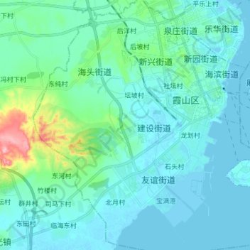
Name: Xiashan District topographic map, elevation, terrain.
Location: Xiashan District, Zhanjiang City, Guangdong, PRC (21.12049 110.31531 21.24295 110.44235)
Average elevation: 22 m
Minimum elevation: -4 m
Maximum elevation: 157 m
Other topographic maps
Click on a map to view its topography, its elevation and its terrain.
Guangzhou City
PRC > Guangdong > Guangzhou City
Baiyun, Baiyun District, Guangzhou City, Guangdong, 510091, PRC
Average elevation: 24 m
Yunfu City
PRC > Guangdong > Yunfu City
Xincheng, Xinxing County, Yunfu City, Guangdong, PRC
Average elevation: 101 m
Guishan Island
PRC > Guangdong > Kuishan island
Guishan Island, Kuishan island, Xiangzhou District, Zhuhai City, Guangdong, PRC
Average elevation: 25 m
Shekou
PRC > Guangdong > Shenzhen City > Shekou
Shekou, Nanshan district, Shenzhen City, Guangdong, 518000, PRC
Average elevation: 11 m
Sha Lo Wan
PRC > Guangdong > Shenzhen City > Sha Lo Wan Chung Hau
Sha Lo Wan, Hong Kong-Zhuhai-Macao Bridge Hong Kong Link Road, Sha Lo Wan, Sha Lo Wan Chung Hau, Islands District, Shenzhen City, Guangdong, Hong Kong, PRC
Average elevation: 43 m