
Łapczyca topographic map
Interactive map
Click on the map to display elevation.
About this map
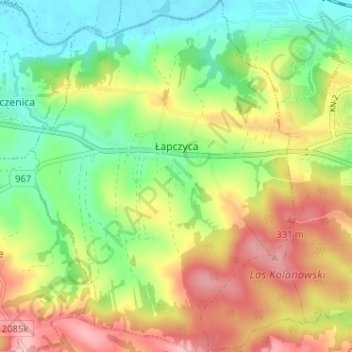
Name: Łapczyca topographic map, elevation, terrain.
Average elevation: 262 m
Minimum elevation: 195 m
Maximum elevation: 349 m
Other topographic maps
Click on a map to view its topography, its elevation and its terrain.
Łapanów
Poland > Lesser Poland Voivodeship > Bochnia County
Łapanów, gmina Łapanów, Bochnia County, Lesser Poland Voivodeship, 32-740, Poland
Average elevation: 266 m