
Maplewood topographic map
Interactive map
Click on the map to display elevation.
About this map
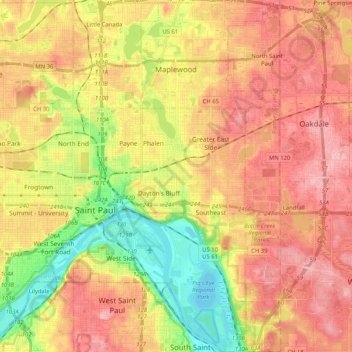
Name: Maplewood topographic map, elevation, terrain.
Location: Maplewood, Ramsey County, Minnesota, United States (44.89078 -93.10597 45.03688 -92.98423)
Average elevation: 279 m
Minimum elevation: 207 m
Maximum elevation: 335 m
Other topographic maps
Click on a map to view its topography, its elevation and its terrain.
Gulf of Minneapolis
United States > Minnesota > Ramsey County > Saint Paul
Gulf of Minneapolis, West Side, Saint Paul, Ramsey County, Minnesota, United States
Average elevation: 230 m
Gem Lake
United States > Minnesota > Ramsey County
Gem Lake, Ramsey County, Minnesota, United States
Average elevation: 289 m
Saint Paul
United States > Minnesota > Ramsey County
Saint Paul, Ramsey County, Minnesota, United States
Average elevation: 268 m
Southeast
United States > Minnesota > Ramsey County > Saint Paul
Southeast, Saint Paul, Ramsey County, Minnesota, United States
Average elevation: 263 m
White Bear Lake
United States > Minnesota > Ramsey County
White Bear Lake, Ramsey County, Minnesota, 55110, United States
Average elevation: 289 m
North Oaks
United States > Minnesota > Ramsey County > North Oaks
North Oaks, Ramsey County, Minnesota, United States
Average elevation: 280 m
New Brighton
United States > Minnesota > Ramsey County
New Brighton, Ramsey County, Minnesota, 55112, United States
Average elevation: 282 m